Burma Road
Distance: 26m / 41km
Profile: View
Grade: Hard

Fitness: High
Time: 5 - 6 Hours
OS MAP: 35
Route Data: GPX KML
Riders: Dave Banks, Brian Gray
Date: 02/06/2013
Summary
A mixture of tarmac, landrover track, single track, bog, with an extreme 3 mile climb, make this an initially hard, but rewarding mountain bike trek through remote and interesting scenery.
Initially this route is hard and requires high levels of fitness.
Details
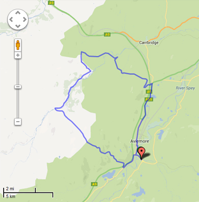
Starting off at the free all day car park at Inverdruie, on the road to the ski centre, a 2 mile tarmac section takes you out to the A9. Having crossed the A9, the route follows a tarmac single track to the Scripture Union Centre at Alltnacriche and gently starts to climb. Just before the you reach the Scripture Union Centre, the route turns to the right and goes through a forest gate. This is where things start to change. The gradient is steep, in fact it is that steep there is a sign that 4 wheel drive vehicles have to engage 4WD before proceeding. You can use your granny gear, but progress is that slow you are just as well walking. The gradient easies off and allows you to get back on your bike again, but not for long. You are soon back off it. This process repeats itself for the next 3m/5km as the track winds its way up the side of the hill. The views back to the Cairngorms make the slog worthwhile.
Just before the summit, there is a cairn. This is the single track that takes you back to Aviemore via the farm at Ballinluig. From here you can admire the views and appreciate the climb you made to get to this point. About 200yds further along the track, the summit cairn is reached. You can see the route ahead as it heads back down the mountain. The landrover track is good, occasional loose stones and a few places have been eroded slightly by water, so that limits your top speed as does the presence of kamikaze sheep that wait for the last second before running across the track in front of you.
The track climbs slightly before you head downhill to the river where the track fords the river. You could however use the new bridge that isn't shown on the map, if you prefer to keep your feet dry. The track from the bridge is a lot rougher as it initially climbs slightly before dropping and running along the valley floor roughly parallel to the river. There are some boggy patches, but the track is reasonably straight forward and progress is good. The countryside is a mixture of grass and heather with the occasional Scots Pine.
The Scots Pines become more dense as the track climbs gently away from the river. There is burn to cross, but wet feet can be avoided as there is a small footbridge to the right of the landrover track. The track continues alongside the river until it once again gently climbs away from it and you come to a gate at which point the main track swings back downhill though the trees. Don't take this track, but take the left fork and head out over the open moorland. This track is quite overgrown with heather in the middle of the 2 wheel tracks and can be boggy in places, especially when it heads into some Scots Pine. Eventually you come across a Y junction and a sign points to the right. We made a navigational error here and should have gone straight on, to join General Wades Military Road at Insharn. Instead, we dropped down through the trees to open grassland and to the ruin at Inverlaidean before a moderate climb to join onto the Military Road further down. This is part of route 7 cycle path.
The landrover track undulates as it follows the contours of the hill with open moorland to the right and a Scots Pine plantation to the left. The track heads downhill to meet the river again at the Military Bridge at Sluggan. From there the track heads up through trees until it joins the single track C road to Carrbridge.
Turn right and head uphill for about 400yds then take the forest track to the left. Once through the forest gate, the track is dead straight and eventually you will come to a cross roads. Continue straight on and soon you will come to a ford on the track. Large boulders at one side make convenient stepping stones and allow you to cross without getting your feet wet. The track climbs away from the ford and the next mile is a bit of an uphill slog. Eventually it heads downhill again where you go through a gate and meet a track coming in from the left. Continue straight on uphill where you will come to a fork in the road. Take the grassier track on the right and continue along this track until you come to a cross roads. Head through the gate on the right and continue until you come to another cross roads. There is a concrete structure buried into the ground on the left, take the left turn and head downhill to out buildings of Kinveachy Lodge. Passing through the yard area takes you to Kinveachy Lodge itself. Continue down the drive and down to the A9. Carefully cross the A9 and continue downhill and a short distance later you will join onto the A95, 4 miles north of Aviemore. Follow the road back into Aviemore and back to Inverdruie.
Photo Gallery

|

|

|

|
|||
|
Road to the Scripture Union Centre |
Burma Road starts here |
4WD Notice |
View back to the Cairngorms |
|||

|

|

|

|
|||
|
Road ahead |
Road approaching the summit |
View back to the Cairngorms |
Cairn marking the single track |
|||

|

|

|

|
|||
|
Summit cairn |
Downhill track from summit |
Ford over the river |
New bridge over the river |
|||

|

|

|

|
|||
|
Rough track from bridge |
Grass track with boggy patches |
Grass and heather track |
Burn crossing |
|||

|

|

|

|
|||
|
Footbridge on right |
Turn left at junction |
Track overgrown with heather |
Navigational error at junction |
|||

|

|

|

|
|||
|
Heading downhill towards Inverlaidean |
Grassy track to Inverlaidean |
Inverlaidean |
Ruin at Inverlaidean |
|||

|

|

|

|
|||
|
Track heads uphill to Military Road |
Turn right onto Military Road |
On General Wades Military Road |
Sluggan Bridge |
|||

|

|

|

|
|||
|
Track heads uphill from Sluggan Bridge |
Looking back on track to Sluggan Bridge |
Forest track on left |
Dead straight track |
|||

|

|

|

|
|||
|
Straight on at crossroads |
Stepping stones over ford |
Uphill slog from ford |
Track coming in from the left |
|||

|

|

|

|
|||
|
Grassy track on right |
Turn left at crossroads |
Buried concrete structure |
Kinveachy Lodge yard area |
|||

|

|

|

|
|||
|
Kinveachy Lodge |
Kinveachy Lodge |
Looking back at the A9 crossing |
A95 to Aviemore |