Loch Einich
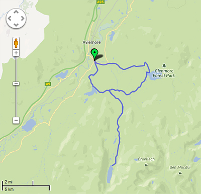
Distance: 24m / 38km
Profile: View
Grade: Moderate

Fitness: Moderate
Time: 4 - 5 Hours
OS MAP: 36
Route Data: GPX KML
Riders: Dave Banks, Brian Gray
Date: 29/06/2013
Summary
A mixture of some tarmac, landrover track, single track and water crossings make this a straight forward and rewarding mountain bike trek through remote and interesting scenery.
This route requires reasonable levels of fitness and is a good introduction for beginners venturing out into remote countryside.
Details
Starting off at the free all day car park at Inverdruie, on the road to the ski centre, turn right and head towards the ski centre for about 200 yds. Take the road on the right at the start of the woods and after about 70 yards there is a gate on the left that takes you on a single track through the woods. There are tree roots in places, but the track is easy going. Continue past the lily loch until you reach the tarmac road leading up to Loch an Eilein. At this point turn left until you reach the car park at Loch an Eilein.
Head up to the loch and take the track on the left traveling in a clockwise direction around the loch, heading through the gate until you come to a small bridge and a junction with the sign directing you to turn left for Lairig Ghru and Glen Einich. The track heads through small Scots Pine and open moorland. A burn crossing can be easily cycled across or if you prefer to keep your feet dry, you can use the small bridge on the left. You will come across a Y junction with a sign pointing left to Loch Morlich. Take the right fork and after a short distance you will come to another junction at a lochan. Turn right here and head through the gate marked Glen Einich.
The countryside is still a mixture of open moorland and Scots Pine and the track gradually heads uphill from this point. You will come to a small ford that can be cycled across, or you can use the small footbridge on the right if you want to keep your feet dry. Directly on the other side of the crossing, there is a Y junction, with a sign requesting cyclists to use the lower path. The path continues to rise gradually as it follows the course of the river down below on the hill side. This track is stonier in places and it also has muddy patches as well, but is generally of similar quality as the other tracks round Rothiemurchas. There is a burn crossing that can easily crossed by using the boulders on the right hand side as stepping stones.
The route to Loch Einich requires the river that was on our left to be crossed, but this is now easily done as there is a small footbridge to the right of the ford, so no need for wet feet. The track has now changed from a single track to a landrover track and is rougher in places with small water crossing along the way. The track still continues to gradually rise, but you don't really notice it that much. You can't see the loch at this point, but its location is given away by the surrounding mountains, so you know there isn't far to go now.
With about 2.5 miles to go, there is a small river crossing. The boulders on the right are not much help, so there is no option but to change into alternative footwear and walk across. The water isn't deep, but even in June, it was very cold. The track rises more noticeably as you head the final stretch towards the loch before a descent and another burn crossing takes you to the head of Loch Einich.
The loch doesn't look as big as the map suggests, and there is grassy areas between the heather and the gravel beach to sit down and have some lunch. The return trip is totally different from the trip in, even though it is on exactly the same route. There is an initial climb as you head away from the loch, but the gradual rise on the way to the loch is now a gentle descent and this allows you to gain some speed. Because of this higher speed, the track which was easy going on the way out now requires more care as you need to pick your line though the stones on the track. Before you know it, you are back at the gate at the start of Glen Einich next to the Lochan.
At this point you can either head straight on and back to Coylumbridge, turn left and head back via Loch an Eilein, or turn right and head to Loch Morlich via the Cairngorm Club footbridge. We turned right and headed through the trees to the footbridge. Crossing the bridge, the track, with its tree roots turns right, and follows the course of the river. Following the signs for Loch Morlich, the single track climbs up through the trees until it reaches the forest road. Turn left and head back downhill, ignoring the junction on the right to take you round the top shore of Loch Morlich until you come to the bridge over the outflow of Loch Morlich and the ski road.
Turn right here and head 200 yards along this road before turning left to join the old logging road back to Inverdruie. Continue uphill until you see the sign for Aviemore and the start of the old logging road. Follow this road until it comes to a tarmac road and turn left, following the sign for Aviemore. After a short distance, just before the road joins the ski road, the old logging road starts again. The old logging road eventually runs out and you have to cross the ski road to join the cycle path on the other side. This path stops at the river crossing, so cycle down the ski road for 100 yards and at the entrance to the caravan/camp site, join the cycle path again all the way back to the car park.
Photo Gallery

|

|

|

|
|||
|
Turn right off ski road onto this one |
Start of single track through the woods |
Take right fork to the Lily Loch |
Tree roots in places |
|||

|

|

|

|
|||
|
Track briefly heads out of the trees |
Approaching the Lily Loch |
The Lily Loch |
Turn left to head up to Loch an Eilein |
|||

|

|

|

|
|||
|
Road approaches Loch an Eilein |
Loch an Eilein car park |
Track from car park to Loch an Eilein |
View across Loch an Eilein |
|||

|

|

|

|
|||
|
Track next to Loch an Eilein |
The track round Loch an Eilein |
Turn Left after bridge |
Track heads out into moorland |
|||

|

|

|

|
|||
|
Typical Rothiemurchas countryside |
Small ford with bridge to the left |
Take right hand fork |
Turn right at this lochan |
|||

|

|

|

|
|||
|
Gate at start of track to Glen Einich |
Landrover track to Glen Einich |
View from track |
Small ford |
|||

|

|

|

|
|||
|
Footbridge to the right of ford |
Cyclists take the lower path |
Single track to Loch Einich |
View to river below |
|||

|

|

|

|
|||
|
Track can be wet in places |
View to river below |
View to river below |
Track follows course of river |
|||

|

|

|

|
|||
|
Track can also be rough in places |
Track drops to meet river |
Small ford with stepping stones on right |
Large ford with footbridge to the right |
|||

|

|

|

|
|||
|
Footbridge |
Single track on other side of footbridge |
Landrover track with water crossings |
Gleann Einich |
|||

|

|

|

|
|||
|
Another small water crossing |
Sgoran Dubh Mor |
Small boulders are no use as stepping stones |
No option but to walk across |
|||

|

|

|

|
|||
|
Loch Einich is still 2.5 miles ahead |
First sight of Loch Einich |
Loch Einich outflow |
Looking back the track from Loch Einich |
|||

|

|

|

|
|||
|
Beach with wild camper |
Cairn at Loch Einich |
Heading back over the ford |
Three possible routes back |
|||

|

|

|

|
|||
|
Single track to Cairngorm Club Bridge |
Cairngorm Club Bridge |
Track with tree routes |
Track follows river |
|||

|

|

|

|
|||
|
Follow signs to Loch Morlich |
Turn left onto forest road |
Heading downhill on forest road |
Go straight on at junction |
|||

|

|

|

|
|||
|
Outflow at Loch Morlich |
Bridge taking you onto ski road |
Turn left onto route to old logging road |
Continue straight on uphill |
|||

|

|

|

|
|||
|
Turn left onto old logging road |
Turn left on tarmac road |
Cross ski road at end of old logging road |
Rejoin cycle path at caravan/camp site entrance |
|||

|

|
|||||
|
Dirt cycle path |
Tarmac cycle path next to ski road to Inverdruie |